
Rus Fm
Type Locality and Naming
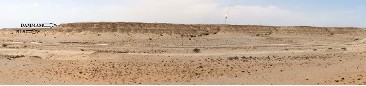
The Rus Formation was first named from the rocks of the Umm er Ru’us (Lat. 26°19’30” N, long. 50°10’00” E), which outcrops on the Dammam Dome in Saudi Arabia (Powers et al. (1966). Bramkamp (1946, cited in Powers et al. 1966) first applied the name Rus Formation as a divestment for the term “Chalky Zone” which had been informally used for Lower Eocene beds above the Umm er Radhuma (UER) and below the Dammam Formation. Thralls & Hasson (1956) wrote the first formal publication which used the term Rus Formation. The same nomenclature was adopted for Qatar by Sugden (1956) and for Bahrain by Willis (1967). Steineke et al. (1958) gave detailed information on the type sequence and Sander (1962) published more details on the stratigraphic and paleontologic data. Detailed descriptions were also provided by Powers (1968) in Saudi Arabia) and Cavelier (1970a) in Qatar).
Synonym:
Reference Section:
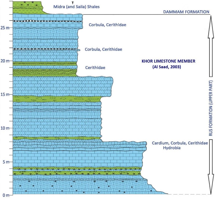
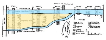
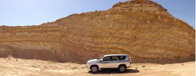
Cavelier et al. (1970a & 1970b) measured and established a reference section for the exposed Rus Formation (about 26m thick) in the cliffs at Lat. 25°17’15.79” N, long. 50°48’12.60” E. Sugden et al. (1975) also reconfirm it in the official stratigraphic lexicon of Qatar (Figs. 3 & 5). The Rus deposits, in the Qatar Reference section area, are variably dolomitized limestones, soft, generally whitish, with minute argillaceous intercalations and green to brown dolomitic marl. Some harder greyish limestone beds, generally dolomitic, intercalate and are the only fossiliferous beds in the section. Some siliceous occurrences (chert & quartz crystal geodes) can be observed towards the base of the section (Fig. 5) that evoke the existence of former levels of gypsum lenses and/or indicate mineralization through the presence of nearby faults.
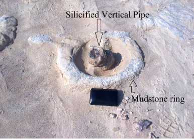
In addition, from LeBlanc (2017)’s investigation, the silica present in an area NW of Dukhan town is related to the tectonic setting of the anticline of the Dukhan oil field and its origin is linked to the silicified remains of the main tubular conduits of paleo-freshwater springs charged with a high content of sulphide (and possibly oil) (Fig. 4). While these paleo-springs can be observed today in the Rus Formation, they were most likely active during the Miocene. The environment that existed at the time must have looked similar to the water-gas-oil seepage taking place today in Azerbaijan.
[Figure 1: Type section locality of the exposed Rus Fm suggested by Cavelier (Sugden et al.1975)]
[Figure 2: Silicified vertical pipe with circular mudstone features around it. The inner axial portion of the ring is bent upward around a near vertical core structure that is also silicified. These structures reach a maximum diameter of 45 cm. Their form and size are consistent with a fluid escape structure. They apparently formed by breaching the sediments of a shallow paleo-sea.]
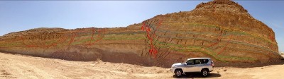
[Figure 3: Qatar Reference Section: Cavelier (1970a & 1970b)’s section at Lat. 25°17’15.79” N, long. 50°48’12.60” E which displays the exposed section of the Rus Formation. The Khor Limestone member’s nomenclature is taken from Al Saad (2003) (see also Fig. 4).
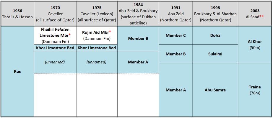
[Figure 4: Members of the Rus Formation over time.]
Lithology and Thickness
The lithology and thickness of the Rus Formation are variable, with most of the variation occurring in the middle unit of the three units described as follows in the table (thicknesses are those of the type section). 85.30 ft (26 m) of limestone is exposed at the Qatar Reference section. The total thickness of the Rus (at surface and in the sub-surface) varies greatly within the country. The minimal known thickness is 91.9 ft (28 m) at Latariyah, NW of Doha, in anticlinal position. In the sector affected by the Simsima Dome (NE Qatar), it varies from 98.4 to 147.6 ft (30 to 45 m). In synclinal position, the Rus is thicker [275.6 ft (84 m) in Doha and reaches 419.9 ft (128 m) at Traina farm in southern Qatar]. In the offshore it displays a thickness of 367.5 ft (112 m) in Idd-el-Shargi; Cavelier (1975) and Al-Saad (2003).
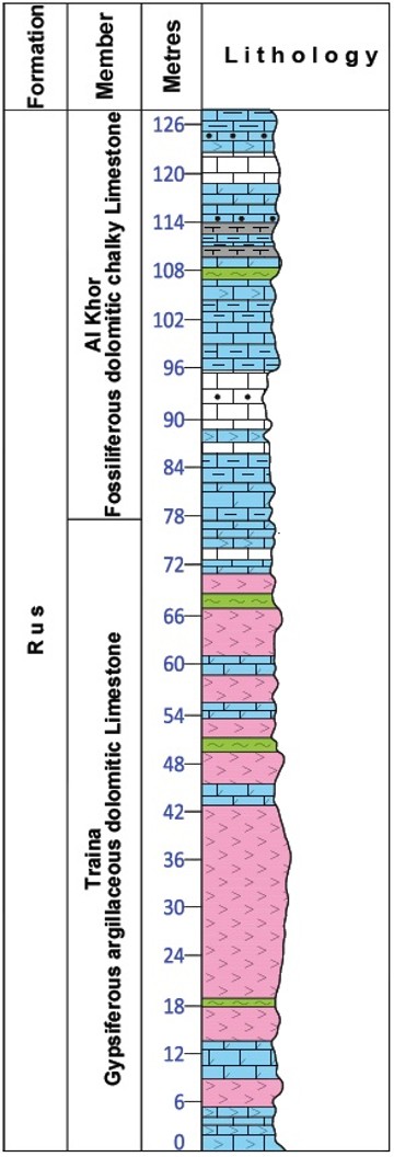
(Sudgen et al. (1975)In Qatar, the Rus outcrops over the Dukhan anticline, in north-central Qatar and in the South by the border with Saudi Arabia (Fig. 8). Boukhary, Al Sharhan (1998) divided the exposed Rus Formation in Qatar into 2 Members (Doha and Sulaimi) and named the unexposed portion of the Rus as “Abu Samra” based on observations from boreholes in northern Qatar. Al Saad (2003) renamed Boukhary, Al Sharhan (1998)’s subsurface “Abu Samra” Member as “Traina” Member from well DW4 near the village of Traina in Southern Qatar. He also renamed their Doha and Sulaimi members to only Al Khor (Fig. 4, Fig. 6).
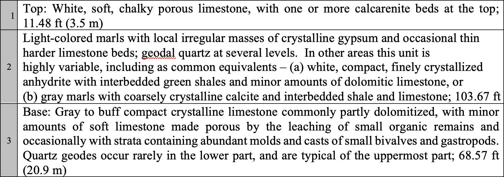
[Figure 5: Table view of Lithology of three units]
[Figure 6: Generalized composite stratigraphic section of the complete Rus Formation in Qatar. Based on Al-Saad (2003)]
Relationships and Distribution
Lower contact
The base is at the contact of dolomite containing Lockhartia tipper Davies of the upper Umm Er Radhuma Fm, with overlying light-colored dolomitic limestone commonly with leached indeterminate molds of small molluscs of the basal Rus. The contact between the underlying Umm er Radhuma (UER) sequence and the Rus Formation in many areas is abrupt. In Qatar it is characterised by the disappearance of a marine fauna and generally by facies change. However, as described below, facies similarity and post-depositional dissolution processes pose certain difficulties in establishing the formational contact locally.
Upper contact
The top is at the contact of light-colored calcarenite layers of the upper Rus, with overlying thin-bedded impure limestone and shale of the basal Dammam Fm. The chronological list of current rock units indicates the next younger unit as Midra Shale Member Fm
Regional extent
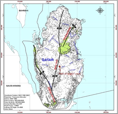
[Figure 7: Occurrences of the Rus Formation at the surface of Qatar in relation to the main structural features of the country (Qatar Arch, Simsima Dome and Dukhan Anticline). It also shows the location of the “Dahl al Misfir” cave in relation to the crest of the Qatar Arch.]
GeoJSON
Fossils
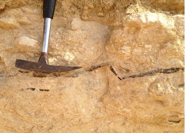
Rare bivalve & gastropod impressions and molds, little diversified, were recognized: Cardium sp., cf. Cuneocorbula, small Veneridae? and especially Cerethidae, such as Trypanaxis cf. daviesi Cox; Cavelier (1975).
Age
Depositional setting
Sander (1962) reports Saudi Arabian fossil evidence from the basal Rus Formation beds which indicate a shallow marine depositional environment. Hewaidy et al. (1993) reports on foraminifera in the formation in Qatar. The abrupt facies change into the Rus Formation over much of the area suggests a possible sedimentary hiatus after the deposition of the Umm er Radhuma. Evidence from Saudi Arabia indicates that the hiatus was associated with uplift and land emergence in some positive structurally controlled areas. With the continuation of sedimentation, the Rus Formation appears to have been deposited in a shallower sea than the Umm er Radhuma. The distribution of facies in the Rus Formation and the thickness variation of the unit, however, show that the depositional environment was variable over Qatar and it is believed that sedimentation was controlled by gentle structural movements. Eccleston (1981) states “deposition took place in warm, shallow, sometimes turbid waters, which resulted in predominantly thinner purer chalk and limestone (with only subsidiary evaporites) in areas of positive structural influence, whilst relatively thicker, turbid and evaporitic sedimentation occurred in the structurally negative areas”. However, some doubts persist with regards to this statement. Restriction and high rates are usually associated with shallow, barred lagoons. Areas lacking evaporites are more likely to have been more open and deeper. May be the lack of evaporites along the crest is diagenetic (Jameson, 2017).
The marked increase in the thickness of the Rus Formation deposits from the structurally high to the structurally low areas suggests that compensatory epirogenetic subsidence was occurring at the time of deposition. The regional distribution of the different depositional environments is shown in Fig. 8. The structural influences are believed to have persisted from the beginning of the Cenozoic and possibly earlier (Eccleston, 1981).
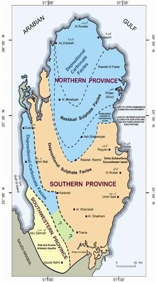
The variable mode of deposition of the Rus Formation has led to two major facies being present in Qatar; these are a gypsiferous, argillaceous, facies termed the Sulphate Facies and a calcareous facies or Carbonate Facies. The evaporitic areas are restricted from marine circulation, thus the reason they have sulphates. They are more likely shallow. The carbonates are open marine, possibly shoals, beaches. Although the distinction clearly exists on a sedimentary basis, post-depositional gypsum dissolution has complicated the recognition and separation between the facies in boundary areas. Fig. 8, Fig. 9 Fig. 10 illustrate the distribution of the two facies and indicate the southward shift to the present-day contact between the predominantly carbonate Rus of the north and the sulphate Rus of the remainder of Qatar due to dissolution of the anhydrite within the formation.
[Figure 8: Surface & Sub-surface depositional facies of the Rus Formation in Qatar (Eccleston, et al., (1981) modified by Elobaid: In Tollenaere (2015)]
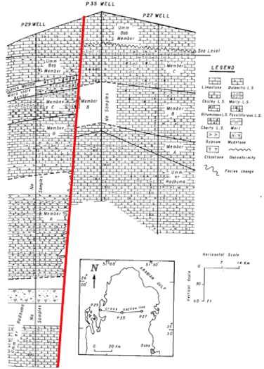
[Figure 9: North-South cross-section of Qatar showing the various lithologies and thicknesses of the Rus Formation (Al-Hajari et al, 1992)]
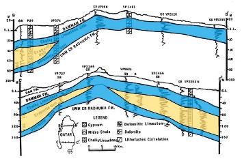
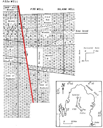
[Figure 10: Two East-West cross-sections in the North & South of Qatar showing the structure, lithologies and thicknesses of the Cenozoic formations, including the Rus; Al-Hajari et al. (1992)]
Additional Information
Faults, Fractures, Folds and Caves: Faults are very much present everywhere in the Formation whether at the surface or in the subsurface but more specifically over the Qatar arch (Fig. 11a, Fig. 11b) and Dukhan anticline (Fig. 13, Fig. 14). Abu-Zeid (1991) studied several wells in northern Qatar which penetrated the Rus Formation in the subsurface and observed two normal longitudinal and transverse faults, the transverse fault having a northward down-throw of about 25 to 30 ft (7 to 9 m). The two faults were also cutting through the younger Umm Bab Member of the Dammam Formation (Fig. 12a, Fig. 12b). LeBlanc (2017) illustrates and interprets a normal fault at the surface over the Dukhan oil field (Fig. 13, Fig. 14).
Minor folds, or compressional deformations, are also visible and frequent in manmade pits cutting through the Rus in the Shahaniya area, located over the Qatar Arch (Fig. 14).
Fractures are also very common and remain the best indicator of the stress experienced by the rocks that make up Qatar today whether over an anticline (Fig. 15) or Arch (Fig. 16, Fig. 17) position.
Our stratigraphic measurements in the Dahl Al Misfir cave (from the entrance of the cave to the bottom) using a "Jacob Staff" and a laser pointer are:
Top
- 18.75m (61.52ft) - Umm Bab Dolomite and Limestone Member of the Dammam Formation
- 01.75m (05.74ft) - Dukhan Alveolina Limestone Member of the Dammam Formation
- 02.00m (06.56ft) - Midra (and Saila) Shales Member of the Dammam Formation
- 15.25m (50ft) - Rus Formation (top portion of the Al-Khor Member)
Base
Total Depth: 37.75m (123.85ft)
In comparison, the measurements taken by Shaw & Cox in 1933 showed a depth of 45.42m (149ft) (LeBlanc, 2015b). The difference could be due to:
- The cave filled up with sediments/debris since 1933.
- Shaw & Cox could have measured to the surface above the roof top of the cave (slightly higher than the entrance of the cave).
- Shaw & Cox could have made some errors in their measurements, or
- A combination of all the above.
[Figure 11a: East-West lithostratigraphic correlation of the Paleogene rock units in the northern region of Qatar showing occurrences of faults cutting through the Rus Fm. (Abu-Zeid (1991))]
[Figure 11b: North-South lithostratigraphic correlation of the Paleogene rock units in the northern region of Qatar showing occurrences of faults cutting through the Rus Fm. (Abu-Zeid (1991))]
[Figure 12: Normal fault seen in the Rus Formation at locality Lat. 25°26’18.95”N, Long. 50°47’3.05”E (LeBlanc, 2017)]
[Figure 13: Interpretation of the Normal fault seen in Fig. 12.]
[Figure 14: Small folds within the Rus Formation in Shahaniya at 25°21'58.04"N, 51°14'27.60"E.]
[Figure 15: Fracture in the Rus Formation located over the Dukhan anticline and filled in with quartz (Lat. 25°29’37.94”N, Long. 50°46’14.99”E) (picture by Kok, Pers. Com.)]
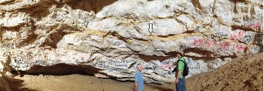
[Figure 16: Few of the many fractures (shown with arrows) and small folds observed in the Rus Formation at the bottom of the “Dahl al Misfir” Cave (Fig. 7), at Lat. 25°10’30.56”N, Long. 51°12’42.23”E (LeBlanc, 2017). See Fig. 18 below for a more general view. People on the picture are: Christian Strohmenger (left) and John M. Rivers (right), both geologists from ExxonMobil-Qatar.]
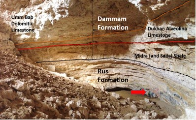
[Figure 17: Rus (and Dammam) Formation in the “Dahl Al Misfir” cave (Fig. 7). Red arrow in the Rus points to the wall of the Rus Formation seen in Fig. 16. The Dammam Formation displays its main members (Midra (and Saila) Shale, Dukhan Alveolina Limestone and Umm Bab Dolomitic Limestone); only the Bir Zekreet Shale and the Abarug dolomitic Limestone and Marl Members of the Dammam Formation are absent at this locality]
https://doi.org/10.37819/biosis.001.04.0134 (or via https://sites.google.com/site/leblancjacques)